



Guide to Choquequirao: The Complete Route to Peru’s Lost Inca City (2026)
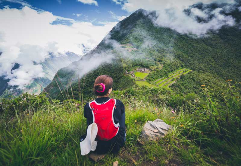
Some hikes exist to get you somewhere. Others exist for the walk itself. The trek to Choquequirao belongs to the second kind. While thousands of visitors line up every morning for the classic photo at Machu Picchu, just a few hours from Cusco there’s another Inca citadel just as impressive, and far larger in terms of unexcavated ground that can still be explored in near silence. Known as the “sacred sister” of Machu Picchu, only a fraction of the complex has reportedly been excavated so far, meaning much of the city remains hidden beneath cloud-forest vegetation.
This guide covers everything needed to plan the route in depth: historical context, a comparison with other Inca routes, a day-by-day itinerary with distances and timing, trek variants, costs, the best season to go, recommended gear, and practical advice from people who’ve walked it.
A bit of history: what was Choquequirao?
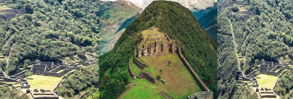
Choquequirao means “Cradle of Gold” in Quechua. It sits above the deep canyon of the Apurímac River, in the Cusco region, at over 3,000 meters above sea level. Given its architectural design ceremonial plazas, terraced agricultural platforms, temples dedicated to the sun and water it’s considered comparable to Machu Picchu in scale and ceremonial function, though with a more mystical character due to its isolation and low visitor numbers. It’s believed to have been one of the last strongholds of Inca resistance against the Spanish conquest, and unlike its sister city, there’s no train, road, or shortcut here reaching it depends entirely on your own two legs.
That difficulty, far from being a drawback, is exactly what draws hikers looking for a more authentic Inca experience, free of the crowds found on more mainstream routes.
Choquequirao vs. Inca Trail vs. Salkantay: which one to choose?
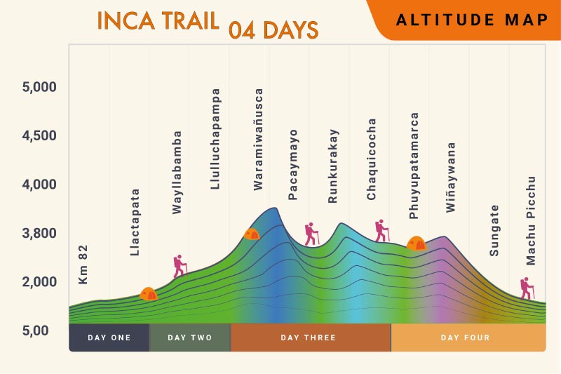
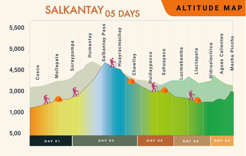
Before deciding, it’s worth comparing Choquequirao with Cusco’s two other well-known trekking routes. They’re not mutually exclusive some itineraries even combine them but each one suits a different kind of traveler.
| Aspect | Choquequirao | Classic Inca Trail | Salkantay Trek |
|---|---|---|---|
| Total distance | 58–65 km round trip | ~43 km | ~60–74 km |
| Typical duration | 4–5 days (up to 9 when connecting to Machu Picchu) | 4 days | 5 days |
| Maximum altitude | ~3,050–3,150 m | ~4,215 m (Dead Woman’s Pass) | ~4,630–4,650 m (Salkantay Pass) |
| Does it reach Machu Picchu? | Not directly (yes on 8–9 day variants) | Yes, through the Sun Gate | Yes, on the final day |
| Permit required | No special permit, only the archaeological site entrance fee | Yes, limited spots, book months ahead | No restrictive permit system |
| Crowd levels | Low lightly traveled route | High regulated by the Ministry of Culture | Medium-high one of the most popular routes |
| Relative difficulty | High, due to cumulative elevation change (descending and climbing back out of the Apurímac canyon) | Moderate-high, due to Inca stone stairs and uneven terrain | High, due to the altitude of the Salkantay pass |
| Approximate cost (group, all-inclusive) | From ~US$250 (independent) to US$600–800 (agency) | US$700–1,200+ | US$450–700+ |
| Accommodation type | Camping (own tent or agency-provided) | Camping in regulated campsites | Camping, domes, or glamping depending on the operator |
| Best for | Experienced travelers seeking solitude and authenticity | Those who prioritize history and a symbolic arrival at Machu Picchu | Those seeking dramatic high-altitude mountain scenery |
Note: prices vary by agency, group size, and included services (gear, meals, camp type). Always confirm current rates directly with the operator.
Key facts about the classic route
- Starting point: Cusco → Cachora / Capuliyoc lookout (4 to 5 hours by vehicle)
- Total distance: between 58 and 65 km round trip, depending on the variant and operator
- Maximum altitude: approximately 3,050–3,150 m
- Minimum altitude: drops as low as 1,450–1,500 m at the bottom of the Apurímac canyon
- Cumulative elevation change: the descent to the river in a single day involves nearly 1,600 vertical meters of drop, which then has to be climbed back
- Typical duration: 4 to 5 days (variants of 2, 3, 6, 7, and up to 9 days exist)
- Difficulty: high not technical mountaineering, but physically demanding due to constant elevation changes
- Permit: no reservation system like the Inca Trail’s, though an entrance fee to the archaeological park is required
Detailed day-by-day itinerary (classic 4-day version)
| Day | Segment | Approx. distance | Altitude (start–end) | Estimated time | Highlights |
|---|---|---|---|---|---|
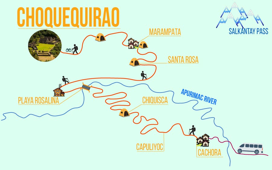
| 1 | Cusco → Capuliyoc → Chiquisca → Santa Rosa | ~15 km | 2,800 m → 1,930 m | 6–7 h hiking + 4–5 h transfer | Canyon views from Capuliyoc, descent through the Apurímac valley, Padreyoc and Qoriwayrachina peaks |
| 2 | Santa Rosa → Marampata → Choquequirao → Marampata | ~10 km | 1,970 m → 3,050 m | 6 h | Switchback climb to Marampata, guided visit to the complex: main plaza, agricultural terraces, temples of the sun and water |
| 3 | Marampata → Santa Rosa → Playa Rosalinas → Chiquisca | ~11 km | 3,050 m → 1,500 m | 7 h | Sugarcane farms, chance to try cambray (a traditional local liquor), swim in the Apurímac River |
| 4 | Chiquisca → Capuliyoc → Cusco | ~15 km | 1,930 m → 2,800 m | 6–7 h hiking + transfer | Final climb and return to Cusco (arrival between 7 and 9 pm) |
This is the most popular itinerary, though timing and the exact camp layout can vary slightly depending on the agency, or if you’re hiking independently.
Route variants: from 2 to 9 days
Not every traveler has the same amount of time or the same appetite for physical exertion. Here are the main alternatives:
| Variant | Duration | Reaches Machu Picchu? | Traveler profile |
|---|---|---|---|
| 2 days / 1 night | Travelers with limited time, willing to do one intense day of hiking (~8 h) combined with transport | ||
| Classic Choquequirao | 4 days | No | The most popular option; balances effort and available time |
| Extended exploration | 5 days | No | Travelers who want to explore the archaeological site at a more relaxed pace |
| Choquequirao + Machu Picchu | 7 to 9 days | Yes, via connection with Salkantay and train | Experienced trekkers with strong fitness who don’t want to choose between the two sites |
The 2-day variant emerged in 2026 thanks to a new Amazon-side route (San Juan–Yanama–Salkantay basin), promoted by the Santa Teresa municipality, which condenses the trek into a single intense day of hiking combined with transport. Even so, the traditional Cachora–Capuliyoc route remains the most traveled and the one with the most proven infrastructure (campsites, mule handlers, trail markings).
Independent trekking vs. guided tour: cost comparison
| Factor | Independent | Guided tour/agency |
|---|---|---|
| Approximate cost per person | From ~US$200–250 (transport, food, entrance fees) | US$450–800+ depending on services and itinerary |
| Logistics | You organize it yourself: transport, food, camp, mule support if needed | Included: guide, mule handlers, meals, tents, entrance fees |
| Gear to carry | All your own equipment, unless you independently hire mules | Mules carry cooking equipment, tents, and several kilos of personal belongings |
| Trail knowledge | Depends on your own experience and maps/GPS | Local guide who knows the route and its historical context |
| Safety net for emergencies | Greater individual responsibility in a remote area with no cell coverage | Logistical and emergency support included |
| Recommended for | Experienced, self-sufficient trekkers | First multi-day trek in Peru, groups, those prioritizing comfort |
Best time to go
| Season | Months | Conditions |
|---|---|---|
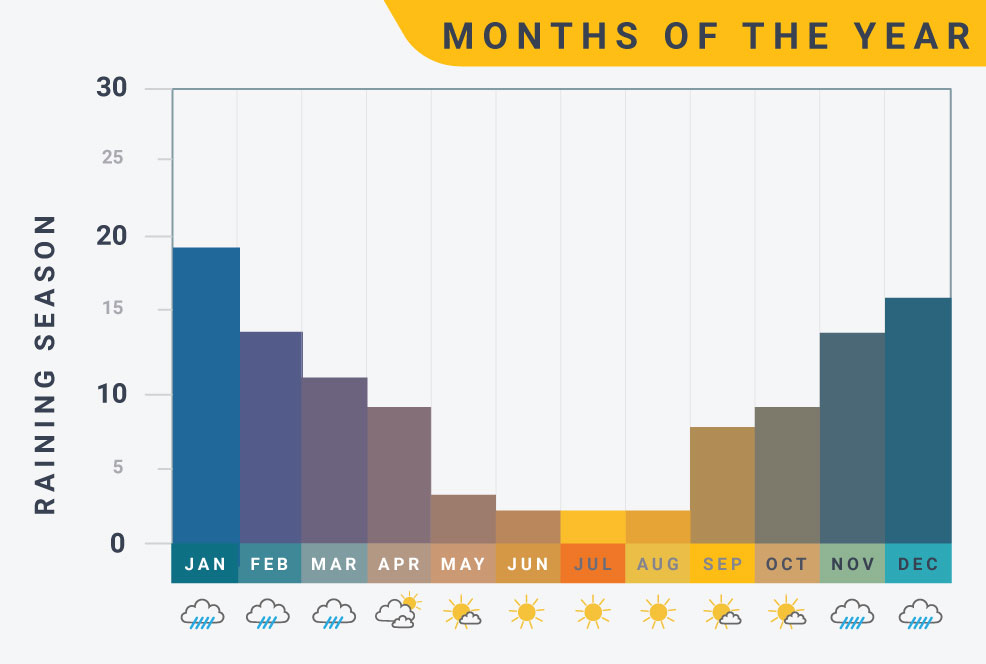
| Dry (recommended) | May to September | Clear skies, firm trails, easier river crossings; best months: May to August |
| Shoulder season | March, April, October | Generally good conditions, greener landscapes, and fewer crowds than peak dry season |
| Rainy (not recommended) | January to March | Heavy rain, risk of landslides and a swollen Apurímac River |
Worth noting: the Capuliyoc–Cachora route officially reopened in April 2026 after a temporary closure caused by early-year rains, so it’s always worth confirming trail conditions before setting out.
What to pack: essential gear
- 30-liter daypack (for what you’ll carry during the day)
- Waterproof backpack cover
- Sleeping bag
- Trekking poles (practically mandatory for the canyon descent)
- Synthetic, quick-drying base layers
- Short- and long-sleeve shirts
- Warm jacket for cold nights
- Rain gear (jacket and pants, or a poncho)
- Hiking shoes with good grip
- Sandals for camp downtime
- Sun hat and a warm hat/gloves for the cold
- Sunscreen and sunglasses
- Strong insect repellent (mosquitoes are intense near the river and in the cloud-forest zones)
- Reusable water bottle or hydration system
- Energy snacks if hiking independently, since food options between stops are limited

Practical tips before you go
- Acclimatize in Cusco for at least a day or two before starting, given the wide altitude range covered (between 1,450 and 3,150 m).
- Watch out for the “false flat”: the trail is visually deceptive, with stretches that look level but involve constant climbing under the sun.
- Book maps or GPS devices in Cusco, not in Cachora, where options are more limited.
- Wifi is a bonus, not a guarantee: some campsites like Chiquisca and Marampata offer paid wifi (around 10 soles per hour), but there’s no cell coverage across most of the route.
- Campsites have basic services: Chiquisca and Marampata sell simple meals, bottled water, and soft drinks, though they shouldn’t be relied on as your only food source.
- The route is considered low-crime, passing through quiet rural areas, and is currently served by more than 20 authorized agencies.
- Not recommended for young children or pets, given the demanding terrain and constant presence of horses and pack mules.

Frequently asked questions
- Is it harder than the Inca Trail? Most travelers and guides agree that it is. The main challenge isn’t altitude (which is actually lower than on the Inca Trail or Salkantay), but cumulative elevation change: descending nearly 1,600 meters into the Apurímac canyon and then climbing that same distance back out the next day.
- Do I need to book months in advance? No. Unlike the Inca Trail, which requires limited permits and advance booking, Choquequirao has no restrictive quota system, allowing the trip to be organized with relatively short notice.
- Can it be combined with Machu Picchu? Yes, 7- to 9-day itineraries exist that connect both sites through a portion of the Salkantay route, ending at Machu Picchu. It’s one of South America’s great adventure treks, though it demands very strong fitness.
- Is there a risk of altitude sickness? The risk is lower than on the Inca Trail or Salkantay, since the maximum altitude (~3,150 m) is lower. Even so, prior acclimatization in Cusco is recommended.
Is it worth it?
If you’re looking for an Inca experience away from the crowds, with landscapes that keep shifting deep canyons, cloud forests, lightly visited ruins and you’re willing to put your body to the test over several days, Choquequirao is the kind of trek that stays with you long after you’re back. It’s not Peru’s easiest hike, but for many who’ve done it, it’s one of the most memorable and authentic treks on the entire continent.